Andres Duany’s urban planning transect: (From 10 diagrams that changed city planning)
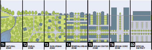
Arguably this is getting out of the realm of art, but it’s still within data viz. I’ll get more playful with the next example, promise. But breaking up cities (and nature) into place types, so we can more expertly address each individual place type, seems very compelling. The drawing here also helps make his point clear: in T5 you’ve got yards behind buildings, in T6 you have straight up buildings, in T2 you have mostly nature with a few scattered houses. Categorizing is the realm of engineering and planning; how can this combine with creativity and playfulness? Are there other ways to categorize parts of a city? Is that even worth doing?
Portals of color, by 1010

The thing I like about these is their sense of mystery. I just started playing the outdoor augmented-reality-I-guess game Ingress, in which you go around and tag “portals” that are public art pieces. I like that it makes it feel like there’s something mysterious around the city. The only problem I have is that it doesn’t go far enough. There are few rare portals; it’s just portals all out in the open and you can grab points by tagging them. These murals point to a similar kind of mystery: there’s a layer under the buildings all around you that you can almost see. I feel like something like that is what I want to pull out in my final project more too.